|
|

|
Contact Streetly Website Streetly Full Site Index and Page Links
| Streetly, Sutton Coldfield, Walsall, West Midlands UK. You may also wish to see more local history information on the Streetly Local History Group page
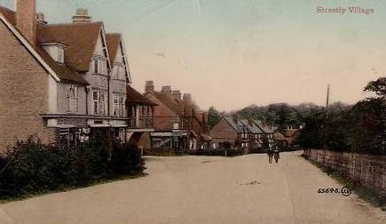
Image of Streetly Village in 1931, in Sutton Coldfield Streetly dates back to Saxon times and derived its name from Ryknield Street, which was a Roman road which ran from the present site of the Parson & Clerk Hotel on through Sutton park towards the rail line. The Anglo-Saxon Charter dated 959 recorded that an estate at Great Barr and Easton (Little Aston) was granted to Thegn Wulfhelm. The earl of Warwick owned Streetly in Medieval times when he resided at the Monor House, Manor Hill in Sutton Coldfield, an area covered in Forest. By the 13th century charcoal burners had cleared much of the original forest, hence the name 'The Colefield'. The land was left as heath and marshland which was described in the late 18th century as "a barren sheep walk containing in some large tracts scarcely any other plants than heath, in other places fern, gorse, whortleberries and rushes with grass in small proportion". Much of the area which then formed part of Great Barr Common was enclosed in 1795 at the behest of local landowners including Sir Joseph Scott of the Nether Hall, Great Barr, and Mrs. E Foley of Great Barr Hall. The land so enclosed was divided and let as 9 farms. In 1879 the Midland Railway Company opened a station at the corner of Foley Road and Thornhill Road and gave it the name of Streetly Station. Development of the district started in Streetly Lane and Foley Road and the adjacent land, all within easy reach of the railway station which formed the main access to the area for most people until well into the 20th century. The station was closed in 1965. Until 1914 housing development was limited to the area between Thornhill Road and the Chester Road. A church was built in Foley Road in 1908 to serve as a chapel of ease to Great Barr Parish Church and a school was opened in Foley Road in 1908. Between 1918, when Mr. Arthur Turner's estate at Streetly was sold and divided amongst the original 9 farms, and 1939, housing development continued in the same area. Blackwood Road was cut through farm land in the 1920's. However much of the area remained relatively rural in character until after 1945. The present amenities such as the Methodist Chapel in Blackwood Road, St. Anne's Roman Catholic Church, the Clinic and the Library in Blackwood Road date from the period 1960-1970 as does much of the housing stock which is privately owned. Streetly remains a very open area which historically was agricultural, but has developed into an established suburb during the 1950's and 1970's to be part of the Metropolitan Borough of Walsall, England. It is adjacent to Aldridge, (see www.Aldridge-web.com) and near to Little Aston and Four Oaks. Administratively, Streetly was in Aldridge -Brownhills Urban District until 1974, when that district was subsumed into Walsall. Positioned from the rest of the Borough of Walsall by 240 acres of park land on Barr Beacon, and therefore has stronger ties with Sutton Coldfield, reflected by Streetly falling within Sutton Coldfield Post Town. The telephone area code of Streetly is also associated with the Birmingham '0121' number as apposed to the '01922' number shared by Aldridge and Walsall making the percieved association with Sutton Coldfield widely accepted. Driving time of about 20 minutes from Birmingham city centre, 15 minutes from Walsall and 15 minutes from Sutton Coldfield town centre. New transcribed details from Aldridge Parish registers completed in October 2010 The Staffordshire Parish Registers Society has published details of baptisms, burials and marriages registered at the church of St. Mary the Virgin, Aldridge, Walsall from 1771 - 1900. Streetly Home Guard is a site which records the life of the 32nd (Aldridge) Battalion, South Staffordshire Home Guard between 1940 and 1944 in Streetly, Aldridge and adjoining areas. Streetly Home Guard Website Personal stories, memories and recollections of Streetly over the years by our readers !
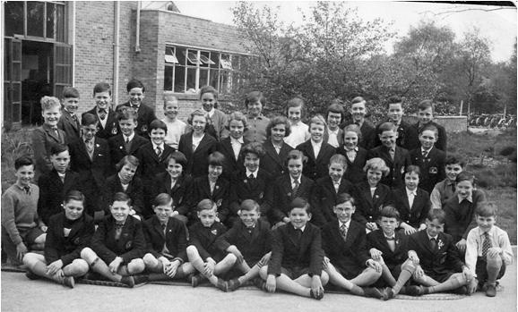
Roger Woodhouse provided his class photo at Blackwood Road School around 1961
Diane Sudhaus nee Crompton from Australia provided the following:
Mr. Ivor Thompson, former MD of BIP Group, an employee for 42 years. Local recollections from Dennis Skett who was born in 1930, and moved to Streetly on 6th August 1955, from Kingstanding. He lived on the Manorial Farm Estate. Manor Farm stood where the Bucaneer Pub was built, much later on. The area was a silver birch wood, which is why so many roads are named after trees. The Midland Red bus stopped at the Hardwick Arms, and went no further.
Mr. Keith Henney recalls memories of Streetly Youth Club, from its very beginnings in the 1940's, to its present day.
Local resident Caroline Griffin provided some local history about Streetly:
The Foley Arms
Foley Road
Chester Road All these items are from Streetly Local History Trail by Charles Robertson 1982 QSH 97 on the shelves in in Sutton Coldfield Local History Library at Sutton Coldfield library, 45 Lower Parade, Sutton Coldfield, B72 1XX. Hardwick Arms in Streetly The Hardwick Arms was built about 235 years ago; it takes its name from the Hardwick Farm which used to be on the opposite side of Hardwick Road. Where the florist, newsagent, shoe shop etc. and BT now stands. For most of the 19th century, the landlord was Charles Powell who was also a farmer and blacksmith, according to the Census Returns of 1841 – 1871. This would suggest that a small forge was operated on the premises for the repair of farm implements. There were also some small fields attached to the property which would have been used for growing crops. A small pool is reputed to have stood outside the inn in 1900 and it is recorded that a small brickyard nearby made Staffordshire Blue Bricks. An interesting photograph of the Hardwick Inn taken by Sir Benjamin Stone in 1908, shows that, as well as being a public house, it also served as the district’s General Store. Information kindly provided by local resident Brian Yates Memories of Streetly County Primary School 1953-58 by Maureen Lea I joined the school on Foley Road after Easter in 1953, starting in Mrs Caulton’s class. She was a wonderful teacher and learning to read and write was a magical experience, I couldn’t get enough of it. The only nightmare was Dinner Time. The food was (I thought) inedible. Everything had lumps and was overcooked. It was cooked elsewhere and arrived in huge vats in a van, like pig swill, we used to say. I was so miserable that they made my Mum have me home to lunch for at least a year. The disadvantage of this was that I missed some of playtime. Mrs. Meanley was in charge of the playground and organised us with Farmer’s in her den, Stalky bluebells, the Big Ship Sails, Oranges and Lemons and other chanting games, not to mention skipping, handstands, tig and other competitive games. At this time, there was a pair of “huts” to the right of the main building; these were Mrs Hall’s class and Mr. Bull’s class. Later 2 other classrooms were built behind them. Behind the huts was the “big boys” playground. I imagined the big boys to be wild and violent, and this seemed confirmed by the fact that Mr Bull used to lean from his classroom window and bellow at them from time to time. After a happy year in Mrs. Caulton’s class I progressed to Mrs. Hateley (the less said the better), then Miss Ralph, stern but fair and kind too, then Mr. Morgan, a lovely man with encyclopaedic knowledge and infinite wisdom; and finally Mrs Hall, who polished us and honed our skills for the 11+, which was a doddle compared to what she expected of us on a daily basis. I can’t thank Mr Darrel (headmaster) and all the teachers of Streetly County Primary School enough for the wonderful start I had in education. The move to Blackwood road was exciting with its woodland setting, beautiful new classrooms and wonderful dinners, provided by Mrs Leonard, who could cook meals for a school which tasted home-made, especially the Lancashire hot-pot. All too soon, I was leaving many of my friends behind to go to the Friary at Lichfield, where my sister was also studying. Most of my friends went to Aldridge Grammar, which had just opened. Other teachers I remember who did not teach me: Mrs Tonks, a young lady who wore pretty skirts; Mrs Baker, a kind, motherly lady; Miss Middleton, another young lady who started a choir, and was very enthusiastic; Mr Bull of course who was very tall and rather frightening to a little girl who wasn’t ever in his class. Information kindly provided by local resident Maureen Lea (now Debenham) Ian Westbury, Growing Up in Streetly in the Sixties. Born in 1947, towards the leading edge of the baby boom era, I moved to Streetly from Stockland Green at the age of 9 when my parents purchased their first home on Elmtree Road. The newly built 3 bedroom semi was on the old Cottage Farm land off the NE side of Aldridge Road between Foley Road and Bridle Lane. At that time I seem to remember the address being Streetly, Sutton Coldfield, Warwicks and much was made of that connection, with greater cachet attached to it than an association with geographically closer Walsall, Staffs! Years later, when we got our first telephone, it had an 021 prefix vs. 0922 which, once again, seemed to be rather significant for some Streetly folk! Ours was one of the first houses on the street to be occupied, and for many months I was in small boy heaven. I met and befriended several other young refugees from ’Brum’ while playing in, on and around all the other partially built houses and the attendant equipment around the building site. Interestingly, in those days, tools and materials were often left where they were at the end of the workday, with little fear of theft or damage…..what a contrast to the present! As families began moving into the homes immediately surrounding ours we got to know the Cowleys, the Hams, the Bristows, the Padgetts, the Yates and the Parkers. A little further down Elmtree Road were the Mayburys and the Stubbs and over on Cherrywood Road were the Parrs. During the evenings and weekends, when no building work was going on, Zorro, the Lone Ranger and Daredevils of the Red Circle could be found tearing around the neighbourhood as we kids aped our idols from the Saturday matinees. The back of our house, and my bedroom window, faced the old farmyard, the barn and the outbuildings, which survived for a number of years after construction was completed. Despite this dilapidated outlook I still enjoyed a largely uninterrupted view of the open farmland west of Aldridge Road with Barr Beacon beyond. At the completion of that first phase of construction of the so called ’Cottage Farm Estate’ around 1960, Elmtree Road ended a few houses past Yewtree Road, Limetree Road ended at Cherrywood Road and there was open land and woods between Hazelwood and Blackwood Roads. Lowlands Avenue ended at Hazelwood Road and resumed again at Blackwood Drive. The paving on Maxholm Road ended at Lilac Avenue, where another friend from Blackwood Primary lived on the corner. Their family name was Meacham. A recent aerial flyover of the area courtesy of Google Earth showed clearly the different house styles dividing that initial Cottage Farm construction from later developments in the area. I attended Blackwood Primary School, as it was called back then, (class photo attached) when it first opened on a site built into the rapidly shrinking Foley Wood. I recall being shown a newspaper article at the time highlighting “The School in The Wood” which, I think, came from the Walsall Observer. Back then the whole area between Hazelwood and Blackwood Roads was still essentially open field and woodland and I was able to get to school by walking across the field and through the remaining vestiges of the wood. I also seem to remember a private school of some sort located on Blackwood Road where Foley Wood Close is now, Sandwell is a name that comes to mind? A little further along Blackwood Road was our doctor’s surgery, where both Dr. Szamocki and his wife practiced out of the same surgery. Back then the intersection of Foley and Aldridge Roads was a simple rural crossroads, no roundabout, no petrol station and no Foley Arms pub. The only retail outlet in the area was Willis’ Store, which preceded the petrol station at the SW corner of Aldridge Road and Beacon Hill. As a pushy kid I talked my way into a Saturday job there helping make doorstep deliveries of groceries from Willis’ to local patrons, under the watchful eye of their driver, who spent most of his time on each trip trying to keep an old J type Morris van from conking out! Spurred by a visit to the Boy Scout World Jamboree in Sutton Park back in 1957 I had joined the 2nd Streetly Scout Troop and eventually aspiring to the dizzy heights of Patrol Leader. Meetings were held weekly in an old wooden building on Blackwood Road that also doubled as a Methodist Church at the time. Unfortunately, my initial enthusiasm to follow in the footsteps of Baden-Powell failed to stand the test of time and I soon found myself unable to continue to ‘do my best, to do my duty to God and the Queen’! Hey, I tried! A regular bicycle trip for me in those days was being dispatched by my mother “down to Slims“ on some errand or other. Bert Slim had a sort of general store at the corner of Bridle Lane and Chester Road which was enthusiastically patronised by all and sundry in the absence of any of the new fangled supermarkets. There was also a barbers on the same corner that I used from time to time over the years. Sidney Ceney always had a gag or pearl of information that he would share….whether you wanted it or not….while clipping and shearing! Going north along Chester Road took me to the home of a school friend from Blackwood Primary who lived above an Ashe & Nephew off-licence run by his parents at the junction of Wood Lane and Little Hardwick Lane. The family name was George. After confounding dire predictions from my father (and several of my Blackwood Primary teachers) with my strong showing in the ‘Eleven Plus’ (remember that?) I was slated to attend what was then known as Aldridge Grammar-Technical School on Tynings Lane in Aldridge. That school was also brand new and couldn’t accept pupils until later in the year I graduated, so my first term was held a strenuous bicycle ride away, uphill along Bridle Lane to Barr Beacon and then a high speed descent of Beacon Road to a secondary school that was then known as Barr Beacon School. The Grammar Grubs and the Secondary Slugs, thrust together involuntarily, struggled to achieve peaceful co-existence! Conflict resumed with new protagonists at Aldridge the next term where the new Grammar School was right next door to the Secondary Modern School. Of course, all this was well before the era of Comprehensive Education. If the weather was fair to middling I would cycle to school and if it was crummy I would catch the Green Bus at the corner of Foley and Erdington Roads, opposite Willis’ and across from where the Foley Arms would be built in later years. During my early teens, having learned about Izaak Walton and ‘The Compleat Angler’, I went through my avid angler phase! I would load up my bicycle with my creel, rods and a pint of maggots and head off to Sutton Park, usually to Bracebridge Pool. Operating on a typical teen budget I would sneak into the Park through the golfers entrance on Thornhill Road, dodging the ‘Parkies’ and thus avoid the price of a ticket……entrance fees were charged back then for us poor ’non-residents’ of Sutton Coldfield! Occasionally I would partner up with a friend and rent a punt to go after the pike that were to be found at the northern end of the pool. Other expeditions from Streetly around that time were to the public swimming baths at Kingstanding, with a choice of riding either a Blue or Green Bus from Bridle Lane or Aldridge Road then changing to a Birmingham bus at Kingstanding Circle. Happy times! Around that time I also took my first underage drink in public, on a dare, at the Hardwick Arms. Two friends and I went down to the Hardwick Arms one evening. We dithered on the threshold of the bar arguing over what we should drink and which of us looked the oldest, to place the order. My idea of a coin toss for the privilege was rejected and my peach fuzz chin proved to be my undoing! We knew that draught beer came in two basic varieties, mild and bitter. Being possessed of above average intelligence, we reasoned that mild was the light coloured, watery stuff while the thick, dark stuff had to be bitter. Further, our logic indicated that as neophytes we would do better with mild for our first experience. All pretty obvious, right? So, I sallied forth to the bar with my most confident air and placed our order….“three pints of mild please“! When the three mugs of foaming dark beverage arrived in front of me I was horrified. Had the barmaid made a mistake? Had I not spoken clearly when ordering? What to do? Not wishing to draw attention to her obvious error I paid up and took the mugs to my pals. Needless to say there was much consternation amongst us until we listened to other orders being placed and observed the results. Ah, the challenges of youth! The Hardwick Arms also figured, indirectly, in the aforementioned motorcycle saga. The traffic light outside, at the corner of Chester Road and Little Hardwick Lane, was the launching point for drag races and speed trials northward on Chester Road down what came to be known as the ’mad mile’. Crouched low over the petrol tank, and securely armed with the assured immortality of youth, we would go flat out down ‘The Mile’ before letting off at the last moment so as to negotiate the bend under the railway bridge at the end. Until 1965 speed limits were non existent outside urban areas and we young ‘immortals’ made the most of the open roads! After O Levels in 1963 I elected to go straight into the workforce and hired on at a manufacturing company in West Bromwich, while studying engineering in the evenings at Walsall Tech. I bought an old BSA motorbike to get myself around but only succeeded in securing an unwanted three week stay at the West Bromwich District Hospital in 1964. After being laid up for a further six weeks convalescing at home, my parents suggested I move onto four wheels. Naturally I dismissed their counsel and bought a bigger and newer bike, a Triumph. That bike introduced me to Tony Dayman who lived on Bridle Lane and John Pritchard who lived on Wood Lane. We rode together all over the place at a time when riding a motorbike defined us as ’rockers’! A popular haunt back then was Dunbars in Mere Green. Eventually it was the reactions of the opposite sex that prompted me to make the move onto four wheels……..the really good looking ’birds’ were more inclined to date a bloke with a car than one who rode a bike! Best Driving School was chosen for the crucial task of preparing me for the transition, their location on Elmtree Road, only 6 doors away from our house, had no bearing on the selection process!
Time passes and youth fades into adulthood. I left Streetly in 1971 to take up a new position in the Glasgow area and started on a career in engineering that took me all over the world, eventually ending up in California USA where I still live today. My parents stayed at Elmtree Road until 1975 and then moved to Tenbury Wells when my father took early retirement. Over the years I have returned to the old neighbourhood several times while on trips back to the UK and have been disappointed to see the deterioration in the area. Urban decay was an abstract concept until I saw the changes in the old neighbourhood. Sad. Julie Bell on Growing Up in Streetly I have just read with great interest the article by Ian Westbury, it brought back many memories. I lived in Aldridge Road from 1954 to 1967 and went to Foley Road infant’s school before going to Blackwood Road Junior School as Ian mentions. I have many memories of being sent to Willis shop, with my list when Mum had forgotten something and taking a look in their back garden at the fish pond. I must have walked past Ian’s house on many occasions as sometimes we would cut through the gulley at the top of Lowlands Ave and walk the long way round to school just for a change. Before the construction of the houses on the right hand side of Lowlands Ave I used to know a couple of people who had horses and sometimes they would exercise them on this open land area and I could have a ride. On the opposite side of Aldridge Road there was ‘Westwood’s Farm’ I would go there to get eggs, It was as very old farm and I remember it being a bit scary for a youngster, as they used to have stuffed birds set in glass cabinets, so I always tried to get a friend to go with me and the lure of seeing the new baby kittens always made it worthwhile. I used to cross the piece of land that Ian talks about when going to Blackwood Road School where Mr Darryl was the headmaster. There were overcrowded class rooms in those days too, during my 2nd year we had 52 pupils in one class you could hardly walk between the rows of desks but discipline was always maintained, the year had to be split and a new class was started. Sports day was always a very big occasion and books were given out as prizes for 1st 2nd and 3rd places, I still have some of the books I won at the time. I was also told never to go into the woods alone, for some reason there were trenches at the edge of the wood and these were just great for riding your bike up and down. The new shops built in Blackwood Road during the 1960’s were great as Grayson’s the newsagents had sweets which you could go and get a mix for 3d or if you were rich 6d, the idea was to get as many sweets as possible for your money. I attended Queslett Road Comprehensive School and remember Mr Farnsworth as a very strict headmaster. As Ian mentions I remember racing round the circle at Kingstanding to catch the bus as it came down the hill to go to Birmingham, there was no through bus route in those days. After 1967 we moved to Erdington Road where I lived until 1971, at the time there was a threat that Barr Beacon was going to be turned into a quarry I think they wanted the gravel for the M6 motorway, this would have been right opposite our house, but thankfully it was rejected It has been lovely to read Ian’s recollection of the area and how similar our memories are. Kindly provided by Julie Bell Nick Barber moved to Streetly at the ripe old age of 10 months in 1969. We lived in Meadow Close just off Foley road east and only sold the house with a few tears in 2009. I went to Manor first school then run by the head Mr Wimbury (or wimbags to anyone below 9). My recollections of Manor First are all fond ones. Teachers that made an impression were Mrs Woods and Mr McGinty. There was also Mrs Roe who was my teacher when my father died and I can remember allowing me extra dressing up time to deal with my grief ! My strongest memory was winning the interschool trophy at the sports day, when every year Foley, Hundred Acre, Manor First and Egerton had a five a side competition on the fields. This was to a 9 year old as near to the world cup as you would ever get. We beat Foley in the final with Mark Gill from Thornhill road getting the winner past Nick Mytton the foley goalkeeper. I moved on to Lyndens middle school when i should have gone to Blackwood. However my brother had been so disruptive there that I think my mother thought that I'd be a marked man. My memories of Lyndens were playing for Slade Celtic who were the only team who could match the blackwood stronghold held by Colron FC. However I only played 3 or 4 matches as a sub ( I was rubbish), but it was nice to play for a good side after recently giving up on the Aldridge Tigers FC who had lost every match for a season. Partly because we were entered in the wrong league (a year too old for us),partly because we didn't care, and partly because our goalkeeper Andy (Noel) Blakemore was so small, any ball above 3 feet off the ground went in. I still see Noel and we both still sing "Tigers" songs after the 8th pint ! Lyndens teachers I remember were Mrs Kendrick (didn't like her), Mr Gaybold (name or description?) and Mrs Peacock (loved her). I can't fore the life of me remember my year 1 teacher but that her name was Margeret but she was the ideal first year teacher, and as near to your mom as you could get. I moved to Streetly school and had a great few years. Memorable teachers were Mr Evans, Mr Maybury (who was as near to the PE teacher from Kes as you could get, but a good bloke) Mrs Ross, Mr and Mrs Kenney, and Mr Beard who could materialise out of walls when you were doing anything wrong. Mrs Williams, Mr Henderson and Dr Graddon also deserve a mention. In all honesty I don't think many of them might look back on me quite as fondly. My abiding memories of my childhood almost all centre around Sutton Park. Jason Wall, Whiffy and me being chased by Parkie after herding cows onto the golf course, or filling in the golf holes. Crayfish catching at the weirs or riding bikes down the weirs. And den building all over the park. We had an array of dens with urinals made of corrogated iron. The hardwick arms in later life was superb and run by Jenny Burrows which was useful as her son Adam was in our year so no age questions as soon as 18. I used to work at wesley service station at weekends and do holiday work at Shrubbery Farm in Aldridge humping Hay bales for Trevor and Arthur, the father and son farming team. Still see T&A Trailers signs now when I return from Sheffield. I still get back at least once every 6 weeks to see my mom. She is now in Aldridge Court Home. What is funny is that Lyndens burnt down in the 80's and we were all met outside the burnt out shell every day and shipped via bus to differing locations. One year we went to Aldridge court and were taught there. My mom now has dinner every day in my old form room. We also spent a year at Doe Bank school. Really surprised that there were no fight between schools that I remember. Was all surprisingly friendly. Kindly provided by Nick Barber Request from South Africa: I have lived in SA the past 35 years and like many ex-pats remember our old friend of former years and wonder what they did with their lives; Like many of the kids some 60 odd years ago in Kingstanding, we were war babies and how wonderful it was to have Sutton Park on our doorstep, I remember Longmore Pool where the overflow went through a place we called the creek on to Powle’s pool. And we would spend a whole day’s adventure tracking through the mangrove swamp to reach Powel’s. One time Nobby Clarke and I decided to walk across Longmore to what was then the new TV mast in Four Oak’s; we had adventure’s all through our childhood in Sutton Park and how fortunate we were, even in the winter snow we would toboggan in our home made sledges, One time we spent all day looking for our lost dog Donnie in very deep snow drifts, and at the end of the day coming home all tired and forlorn; found the dog had been back home most of the day. Later when I grew up and got married we bought a house in Banners Gate and lived there for about 7 years before coming to SA. This was in the Maggie Thatcher era; winters of discontent. John Clarke, one of my best mates could well be in any part of the world, and I’ve tried unsuccessfully so far on the internet, but he does have an older brother David, and if still alive would more than likely still be living in the Midlands, (this is the David who worked at Lewis’s Bull St B,ham ) I have been in contact with an old mate recently on the web who has become an author of several books in his later years, his first book based on a true storey of one of the biggest unknown British covered up heists of all time; called THE LAST VIKING by Ron Dawson And that was quite exciting. There are some others in the same area that would be of interest;( David Dillon, Colin Williams, from Parkeston Cres, ) (Stanley Fellows, Allan Gardner, and friends, N A B C. Boys club these were Biking and camping pals, My nick name was Butcher Bates as I invariably used to have to do an errand to the butchers, before I could join them in some outing on our bikes, ie Tamworth, Litchfield, Kennelworth, Warwick Castle, Stratford, etc. Thanks very much for your interest, hope this gives enough insight to my old friends and acquaintances out there Kind regards Bob Bate, South Africa.
|
Did you see any errors on this page ?
© Copyright Alan Neath. 2005 -- All Rights Reserved
please let us know !